This blog is about travelling through Japan on a bicycle. Initially on a foldable bicycle (Brompton) and more recently mostly by road bike (Spezialized)... but also by train, ferry, plane, bus or any other transport, if sea, weather, mountains or the like come between me and my desire to ride.
I have tried to summarise information that could be potentially helpful also for other bicycle travellers through Japan, such as list of bicycle roads, helpful web pages etc.

Friday, 10 May 2024

GW2024 D8 Yufuin to Nakatsu

Route: Yufuin - Kusu - Yamakuni - Nakatsu
Bicycle: 96 km
Total ascent: 1105 m
Average speed: 16,2 km/h
Riding time: 5:53 h
Weather: very sunny, warm but not too warm, 26C


I had read about a cycle path in Northern Kyushu years ago when I prepared for my 2 months cycling adventure through Japan on my brompton, but I didn’t spend that much time in Kyushu back then and that cycle path seemed to be out of the way. However this time I managed to build it into my course. 

But I wouldn’t say that this cycling path was the highlight of the day. It want bad, but Kyushu mountain roads are better.

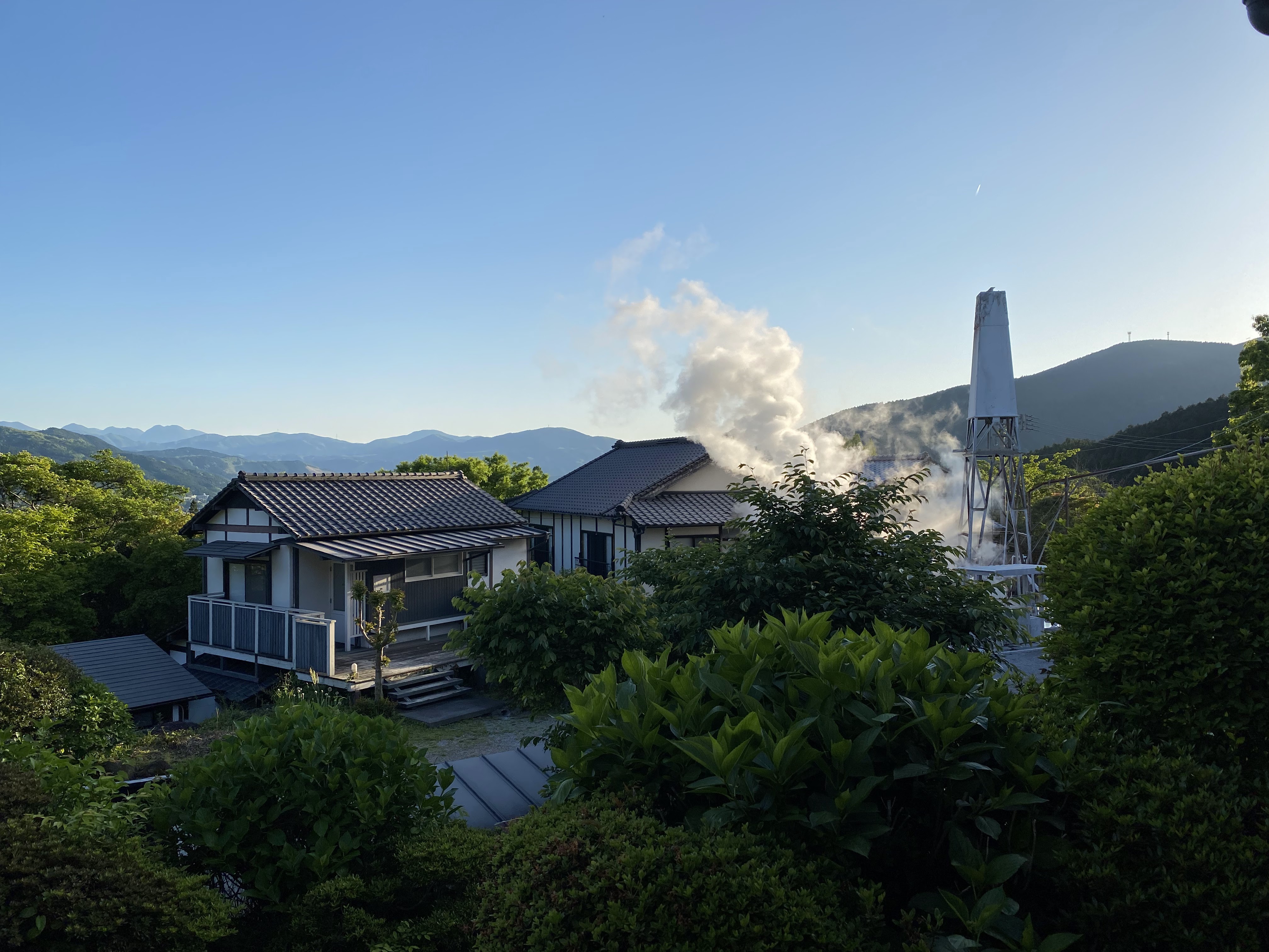
I started the day with this view from my hotel window. 

A small lake in Yufuin, which seems to be a nice onsen town, a bit different from your normal onsen town as the center of the city doesn’t have ryokans all lined up but rather a shopping street and a park and the onsen are more on the outskirts where this small town already merges with the farmland.

I didn’t linger in Yufuin and started my ride, the longest of my rides here in Kyushu but with the last 40 km or so downhill or flat. However I still managed to rack up over 1000 meters of climbing. Yes, there was some climbing straight out of town, later in it was more an up and down affair. 

Climbing out of town I came through a vast training ground of the military. It probably took me about 1/3 of the ride to cross that area. Not only due to that training ground this area was mostly void of population. Just rolling hills without forests, which is special for Japan, where elsewhere it seems there are forests everywhere (or fields). Wide open grass landscapes I so far only connected with Hokkaido. 

I had lunch in a very old , small restaurant in Kusu. Run by 3 very old people, probably all of them into their 90s that seemed to use the restaurant more as their living room rather than a restaurant business. At least they were pretty surprised to have a client, but managed to cook a curry.

From there you nice again into the mountains and countryside on roads with names but with hardly any traffic. In some areas so few traffic that one wonders why such a road would even exist. And this lack of traffic is also a reason why the cycling path wasn’t such a nice discovery. That said, where the cycling path is the main road actually has a lot of traffic, so definitely very good to have the path. 

But before that through the mountains I came by two places with these rock formations. 

The cycle path is on an old railway track that was decommissioned in the early 1970s and winds it path through the valley, through tunnels and over a few old railway bridges.

The day ended with an other view over water, this time the ocean.

However, what could be a very nice view of the ocean is actually hard to get to and totally cordoned off. Quite typical for Japan, a country too afraid of natural disasters to just enjoy the nature. Most rivers are heavily regulated, the view of the ocean often blocked by flood prevention dams (instead of nice green dikes like in the Netherlands) or the highway runs along the shore and blocks all views and sounds of the ocean. It’s strange for a country with so many hikers and so engrained appreciation of nature and the change of seasons. But control of nature is more important than nature itself. Probably because of that Japanese flower arrangements are ikebana, a very controlled way to represent nature. 


Thursday, 9 May 2024

GW2024 D7 Through onsenlandia

Route: Kurokawa onsen - Sujiyu onsen - Tadewara wetlands - Ukenokuchi onsen - Yufuin
Bicycle: 59 km
Total ascent: 1193 m
Average speed: 11,3 km/h
Riding time: 5:15 h
Weather: blue skies but surprisingly cold, maybe around 12 C


What a view!

Mt. Aso in the background with the smoke coming from the caldera, a few other mountains connected to Mt. Aso, the rolling hills and high plateau in front and the edge of the caldera that surrounds Mt Aso. 

And all this by chance as I took the “wrong” road. I wanted to take Yamanami highway, but the small connection road that Komoot saw didn’t exist in reality, and the next option that wahoo saw didn’t exist in real life either. So I continued on the small road I was on until it joined a bigger road but at that point I was already at least halfway up the mountain and cycling down just to join Yamanami highway didn’t seem a good idea, when this road was going in the same direction and had hardly any traffic.

This ski slopes were the highest point of the ride, I donned my rain jacket to not freeze on the downhill and down I went  … 


… until turning towards the Tadewara wetlands.

Not sure if I was impressed by the wetlands themselves (they were green but no special flowers in bloom) but the backdrop of Mt Kujo, apparently an other active volcano, was majestic. 

From there it wasn’t very far to the next attraction, a swinging bridge over a small and very deep river with its waterfalls. And although this place is quite hard to reach, it seems relatively popular with bus loads of foreign tourists. 

From there on through small streets, one actually a bit too small (and steep) to be enjoyable to ride… but it fooled me as the beginning of that road (only the first 100m or so) were newly build and thus in perfect shape… to my destination: Yufuin.

Once here I went to the local onsen on a hill behind the main city, with a huge rotenburo (but no internal tubs) ..


… and with the boiling hot onsen water coming out if the ground around it.


And then down to my accommodation 


Wednesday, 8 May 2024

GW2024 D6 through rolling green hills to Kurokawa

Route: Asoshirakawa - Namino - Milk Road - Yamanami Highway- Kurokawa onsen
Bicycle: 59 km 
Total ascent: 1197 m
Average speed: 13,6 km/h
Riding Time: 4:22 h
Weather: surprisingly cold and in the first half of the day some light rain, 14 C


Back on the move after 4 nights in Southern parts of Aso now onwards to Kurokawa onsen, where I stayed a few years ago in a previous trip to Kyushu and enjoyed soaking in different onsen. 

My route today brought me through some very unique landscape, kind of more what I would expect in Hokkaido rather than Kyushu: Rolling green hills. 


Until I came to Yamanami “Highway” the roads had barely any traffic but were good roads. Probably needed for agriculture or they were built when there were more people in this area, but now there is hardly any traffic at all. 

Right when it started to rain I found this school bus stop where I took a rest, ate and onigiri and by the time I had finished the rain had stopped and I continued. 

Rain did restart a bit later, still quite light but for mid May it was surprisingly cold. At the point where Milk Road (probably named after all the dairy farms) joins Yamanami highway (called so probably for the wave-like rolling hills) there was a farm which offered horse riding but also had a restaurant. And warmth! And protection from the drizzle.

Per the weather forecast it should have become more rainy as the day went on, but rather after lunch the rain had stopped and occasionally there were even a few sun rays piercing through the clouds. However I had decided to head directly to Kurokawa onsen to have more time to soak (knowing that the one onsen I wanted to visit closed at 15:00) rather than riding more and potentially getting soaked by rain instead of hot sulfuric water.

Someone build this garden with hundreds of trees carefully carved into shapes. Mostly birds, but also some other forms.

Through more rolling hills to the bottom of Kujo mountain and then downhill to Kurokawa onsen and right into the bliss of Yama-Mizu-Ki onsen. 

They did change the layout a bit since last time o was here but the rotenburo is still very much in the middle of nature. Today even with wild wisteria blooming in the forest across the small stream. When I arrived I was the only person, so took the opportunity for a picture. 

I was there probably around 13:30 and left shortly before 15:00 (when they close for day guests) soaking blissfully in the warm water on a coldish day. And then on to my ryokan in town, which obviously also has an onsen, where when I passed no one was using so I took a picture of that one as well. 

After checkin a quick stroll through the village …

… and then some relaxation time  and more onsen before an early dinner.

Tuesday, 7 May 2024

GW2024 D5 Full circle of Mt. Aso

Route: full circle of Mt Aso
Bicycle: 70 km
Total ascent: 946 m
Average speed: 14.2 km/h
Riding time: 4:57 h
Weather: quite windy, cloudy, 20C


For today my plan was to do a full circle of Mt Aso. There are different ways how to go about it, I took the easiest. 

The day started with a fountain, that gushes out 60 tons of water every hour. If I calculated correctly that’s 1 m3 every minute. And this is only one of the many fountains around here. Not really sure why, but it seems that at the foot of this volcano there are a lot of water fountains in addition to all the hot water fountains. 


My next stop was a strategic stop at a conbini which here are few and far between to stock up on onigiri in case I don’t find a place to have lunch. And then onwards through this very rural landscape that in many places reminds me of Bavaria. Without the riches though. This area here is clearly depopulating and although there is great tourist potential it isn’t enough to keep the place afloat. The other day there was a study published saying that more than 40% (!) of Japanese municipalities will disappear. The ones here seem to be on a straight road to that unfortunate end. 


My third stop of the day was at a shrine that was recommended and has a name impossible to remember: Kamishikimi Kumanooza shrine. A long staircase, even longer than its name leads up to the shrine …


… and then further up to this hole in the mountains ridge. 


From here it was another 6 km or so to the highest point of the ride today.  Unfortunately though the ride down wasn’t very enjoyable due to the strong winds. But the landscape is really nice. 


In Aso I went to visit the famous shrine, which to me looked like any of the bigger shrines in Japan. This one was heavily damaged by the 2016 earthquake and they just completed reconstruction of the big gate. 

From here it was a long ride through the valley battling against the wind. 

My Minshuku owner had warmly recommended a visit to the earthquake disaster museum. The museum was closed today, but one can enter freely the area and see the old Tokai university that was sitting right on top of one major fault line that burst open. 

The day ended with yet another fountain, very close to my Minshuku.


Monday, 6 May 2024

GW2024 D4 onsen in the rain and train

Route: Asoshirakawa - Tochinoki - Choyo - Asoshirakawa
Bicycle: 0 km
Walking: 5 km
Bus: 11 km
Train: 9 km
Weather: rain and more rain all day, 20 C


Today will hopefully be the only really rainy day for this week. It started raining during the night and hasn’t stopped yet. Luckily today isn’t a day where I need to get moving to my next accommodation, so I could do rain weather activities here in Minami Aso. There aren’t many but surprisingly I managed to do two:

Relax in a very nice onsen with views and take a theme train. 

I had asked the owner of my Minshuku yesterday what he would recommend for a rainy day and after excluding to go strawberry picking and a garden in a tunnel (it seems there were plans to build a railway to Takachiho and they started digging for a tunnel when they found too much water and gave up. Somehow that tunnel is now a garden!?) I settled on an onsen that was reachable by public transport, aka the neighborhood bus. This onsen got damaged by the earthquake but has since been restored and has a very nice rotenburo with a real view of the narrow valley. You don’t find too many of those. Before going to the onsen I had some fried chicken at this very retro place. Retro without wanting it to be retro. Still original including the two elderly who are running it and the television series they were watching in an old style “tailed” TV. 


It turned out that I didn’t have that much time in the onsen, if I wanted to catch the bus back. I hadn’t checked but there was actually a train, which I ended up taking, because I arrived 30 min too early to the bus stop. (Walking times were kind of hard to calculate and with only 4 busses a day you can’t miss the one you are aiming for. At the train station was a small coffee shop where I got 2 cupcakes for the price of one plus a free cup of tea while waiting for the train. Which turned out to be a special train. In front a torokko train (a kind of sightseeing train where you can’t close the windows) and in the back a OnePiece manga themed carriage, which I took. The train went very slowly explaining where you could see some OnePiece characters and even a green house with famous local “red” cows, which the train conductor introduced as very tasty. 
Now just remains to hope that the weather forecast for tomorrow is correct to state that it will not rain. 

Sunday, 5 May 2024

GW2024 D3 Aso crater

Route: Asoshirakawa - Mt Aso - Tarutama onsen - Asoshirakawa
Bicycle: 41 km
Total ascent: 1035 m
Average speed: 10,7 km/h
Riding time: 3:50 h
Weather: very, very windy, not too warm


On the first day around Mr Aso I immediately embarked on the mission to ride up to the crater of the most active volcano in Japan. 

The crater just recently got reopened after it was closed off for years due to too much volcanic activity. I had been (by car) a few years ago, and could only get to an information center at the bottom of the crater from which however it was impossible to actually see the crater. 

From my Minshuku the access road to the volcano is very close and the climbing starts. It was never really too steep but in some places , specially at a view point maybe 1/3 up the wind was fierce. 

But I continued on. Midway through the climb one comes through what I would call an “Alm” with short grass and cows munching away. 


Although I was afraid of the wind and possible cold of the descent I continued on and came to a plateau below the crater with a gift shop and a large parking lot. I had a grilled sweet potato and then tackled the last few kilometers up to the crater. For cars and motorcycles there is an entrance fee to pay, but not so for bicycles. I tried riding it up but somewhere midway through the wind became too strong (combined with the gradient that o pushed the bike for a good part of the last climb). On the top I found a parking spot …

… and then set off for a quick visit to the crater after donning my long sleeved layer, hat, neck warmer and rain jacket. Luckily that combination was warm enough for walking around. 


Right around the crater are also these emergency shelters in case the volcano should decide to use exactly that moment to erupt. Well, I guess for full blown eruption these shelters wouldn’t help , but they could be useful for some flying ashes. They surely don’t look nice.


After seeing what there was to see I walked my bike down too much in fear of the fierce winds, had another short break at the souvenir shop and then decided to start the descent. There is actually an other sightseeing spot up there famous for its long grass landscape but I was quite afraid of the descent and didn’t know if with the wind I would be taking ages to make it down safely. Luckily it was much easier than I hoped and I was neither blown away nor frozen to death during the descent. At around the cows I stopped and turned right on a small and not well maintained road down to Tarutama onsen, an onsen that was highly recommended by the owner of the Minshuku. And rightly so. Coming from the top I first passed through the source area of all the onsen bonanza which duefully smelled of sulfur and bubbled in hit mud. 

Before getting to the two onsen. I took the one that I was recommended also because the other one requires you to wear a dress as there is a mixed onsen and I can’t really fathom sitting in a soaked cloth in an onsen. Later on I learned that today it closed early anyway. 

I went instead to Tarutama onsen, a probably historic onsen, but recently rebuild and done quite slickly. A bit like onsen in Karuizawa. In tge female section TGERE was one big internal pool and 3 different rotenburos one doesn’t have a real view of the valley but still it feels a lot like sitting directly in nature. The sulfur small surprisingly isn’t that strong. 


After relaxing I departed down around 16:00 and then had to search for a place where to have an early dinner. As the Minshuku owner said a lot of places around here close early. Maybe around 17:00, but I found this meat grill restaurant with a great view and very tasty pork meat. 
From there it was a last few kilometers into the head wind back to my minshuku. 


Saturday, 4 May 2024

GW2024 D2 Kumamoto to Minami Aso

Route: Kumamoto - Jizo toge - Minami Aso 
Bicycle: 67 km
Total ascent: 1461 m
Average speed: 12.5 km/h
Riding time: 5:52 h
Weather: sunny and warm, but not too warm, 25 C


Today I crossed over from Kumamoto to the caldera (is it one?) around Mt Aso. I knew that the road with least elevation was going to be busy so I had planned for an alternative route, but surprisingly also that one was pretty busy. Luckily I got fed up of that traffic at the right moment, just when there was a turn to the right that lead to the starting point of yet another road over to minami Aso over a higher pass, but using a very scenic route that wasn’t so busy with cars, but beloved by motorcyclists. 


Midway through the climb I had seen on google maps a restaurant. It turned out that it was a huge attraction farm for which one needed to pay an entrance fee to get close to the cows, horses and sheep. And the food. I had no interest in the living animals and it seemed way too crowded to be able to eat in a restaurant in there, so I had on the parking lot an onigiri I had bought earlier at a conbini. 


But I did use the bathroom, water and vending machine to restock on fluids and cool myself down with abundant water. 


From there it continued uphill but never too steep with nice views. On the very top of the pass a cloud was lying in waiting. Same cloud that did engulf Mt. Aso. 


These grass lands seem to be typical of this region. 


In the distance some dark clouds but they never resulted in any real rain. Down , down and slightly up on the other side to my guest house for the next 4 days. With a very friendly host who has a Thai restaurant next door which seems to be one of the few places open after 17:00. 

Before dinner though I went to the closest onsen. A huge installation with (at least today) a lot of guests, but closed restaurant and closed rotenburo. 

Friday, 3 May 2024

GW2024 D1 to the start: Kumamoto

Route: Home - Tokyo station - Kumamoto station - hotel
Bicycle: 19 km
Train: 1200 km
Riding time:
Weather: very sunny and probably around 27C

Starting my week of spring vacation. This year not precisely Golden Week, but the week after as my colleague wanted to take GW. 

Today was dedicated to getting to the starting point: Kumamoto. I left home around 7:30 to be at Tokyo station around 8:30 and have enough time to pack up the bike, buy breakfast and lunch for a 6 h journey, and be the first in queue for my seat. I had a reserved seat, mandatory now for Nozomi Shinkansen during high peak travel season.  

Originally I wanted to pack up my bike with both wheels removed, but it turned out, that I was incapable of removing the rear wheel. I tried it at home, so no panic when I got to Tokyo station. Luckily there was one person in the baggage seat row who didn’t have baggage so we were only in 2 with oversized baggage which meant that there was more than enough space for my bike. 

Kumamoto is far from Tokyo and flying would seem the more reasonable way to get here, but flight tickets aren’t cancellable, while train tickets are.  I had reserved hotels in Kyushu but also reserved alternative hotels in Tohoku and Nara prefecture many months ago that could be cancelled until a few days prior to departure. On Wednesday this week I looked at the weather forecast: Weather for this week looks ok for most days, except Monday which will be very rainy. So likely a day for relaxing in an onsen. 

While today it was brilliant weather everywhere but I was sitting in the train for most of it. 

Once in Kumamoto it was actually to late to visit anything, but I still went to the castle, took a few pictures and relaxed in the park under a huge , old tree writing some delayed blog posts of recent rides. 

The castle was damaged 8 years ago by a massive earthquake and is now under reconstruction.